 |
The
Course
The course : Mostly flat, on hard surface. Run on the left throughout. The course has been accurately measured based on the left edge of the road, so do not cut the corner at right-handed bends (esp at the far end of Aberlady, and shortly after the turn up into Dirleton).
There will be distance-markers at 1 / 5 / 10 / 15 / 19 miles. There will be lead- and tail-cyclists.
The Route : Generally straight / eastbound / obvious,,, apart from 3 points where you need to hang a left (but they will all be signed)... into New Street, Musselburgh (2.2 miles); at Levenhall roundabout (4 miles); and up into Dirleton village (17.2 miles). At a few points on the course you may see orange arrows on the ground showing the correct way.
Water-stations : There are
three, with plastic cups: water on first table, orange juice on second. And first aid kits.
1 : at 4.9 miles, Morrison's Haven car-park (Prestongrange)
2 : at 9.8 miles, Longniddry Bents car-park no.2
3 : at 15.1 miles, start of Gullane
Toilets : Free public toilets at Longnniddry Bents car-parks nos. 1, 2, and 3 (c.9, 10, 11 miles).
Paths / Roads : For the great majority of the route you will be running on promenades, paths, pavements, or shared cycle-paths. But you will have to run on the road for the following two sections: (A) from the east end of Seton Sands (at 9.2M, for about 3 miles, until the entrance to Aberlady); and (B) on the approach into Gullane (at 14.1M, for about 1 mile,,, although there is a cycle-lane marked on this bit). On these sections ‘Runners on Road’ signs will be positioned at regular intervals to alert drivers.
Runners should show consideration for other users of paths and pavements, if necessary running wide or onto the road to avoid pedestrians / buggies / small kids / dogs.
N.Berwick / Finish : The final mile in North Berwick is almost straight, on pavements. The finish is on the grassed area just beyond the putting green; see map below.
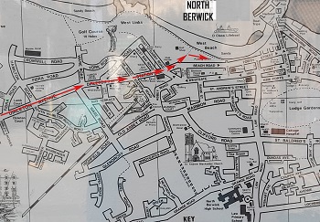
Googlemap of the course (below)...
|
|
|
|
|